Please share my lesson using your social media platforms. Use the links above.

Student FREE Bookstore (CLICK HERE)

https://www.fiverr.com/s/YDrPkl
At Conservation International (CI), we like to say, “People need nature to thrive.” But behind that statement are countless questions revealing a more complicated reality: Where is the nature that people need? Which places are most important to protect? And how much can we chip away at various ecosystems before their value is compromised?
Take Cambodia, one of the poorest countries in Asia. The nation’s 15 million residents are directly dependent on nature for fish to eat, drinking water and meeting other basic needs. As the Cambodian government strives to develop the country’s economy and improve the lives of its people, it must balance development with the need to maintain the lifeline that nature provides for people.
If nature is not adequately protected, human well-being will ultimately decline. Figuring out which places and resources are most critical to conserve is the first step.
To help countries meet this challenge, a team of scientists at CI has developed a framework for mapping essential “natural capital” — the biodiversity and ecosystems that support human well-being. Cambodia was one of the first places we tested it out.
How do we map nature’s worth?
Here’s how it works.
First we hold a workshop with local experts and ask them: How exactly do people depend on nature in your region? Where do they get their food, drinking water and energy? What are their primary livelihoods? What are the most important “ecosystem services” — the goods and benefits provided by nature? Which ecosystems are most important for providing them?
CI’s strategy focuses on several key types of natural capital — components of nature that are important everywhere on Earth. These include areas that are essential for:
- biodiversity, such as areas important for threatened or endemic species;
- climate mitigation, such as forests and mangroves that absorb and store carbon;
- climate adaptation, such as coastal ecosystems that protect people from flooding and sea-level rise;
- fresh water, such as wetlands that filter sediments and pollutants out of drinking water; and
- food security, such as marine and coastal fisheries.
For example, Cambodia contains populations of unique, highly threatened species such as pangolins. Its forests contain stocks of carbon that, if conserved, help to reduce global climate change. Its forests and wetlands filter and regulate flows of fresh water, providing clean water for households, fisheries and rice agriculture that support millions of people. Its Tonle Sap Lake — the world’s fourth-largest inland fishery — provides the main source of protein for one-third of the country’s population.
Once we’ve identified these specific benefits from nature, our next step is to collect existing data. These can include maps of biodiversity priority areas, land cover, climate change models or other data on species and ecosystems. We also collect socioeconomic data on human populations and use of natural resources, such as household demand for water, fish, fuelwood or other products. Next, we conduct spatial analyses to link these data together using tools such as geographic information systems (GIS) and WaterWorld, a freshwater ecosystem services modeling tool.
To analyze the importance of ecosystems, we assess the magnitude of the benefits provided (measured in tons of carbon, cubic feet of fresh water, number of threatened species or other relevant units), the number of people who benefit, or other criteria. If an ecosystem scores above a certain threshold, it’s identified as “essential” natural capital.
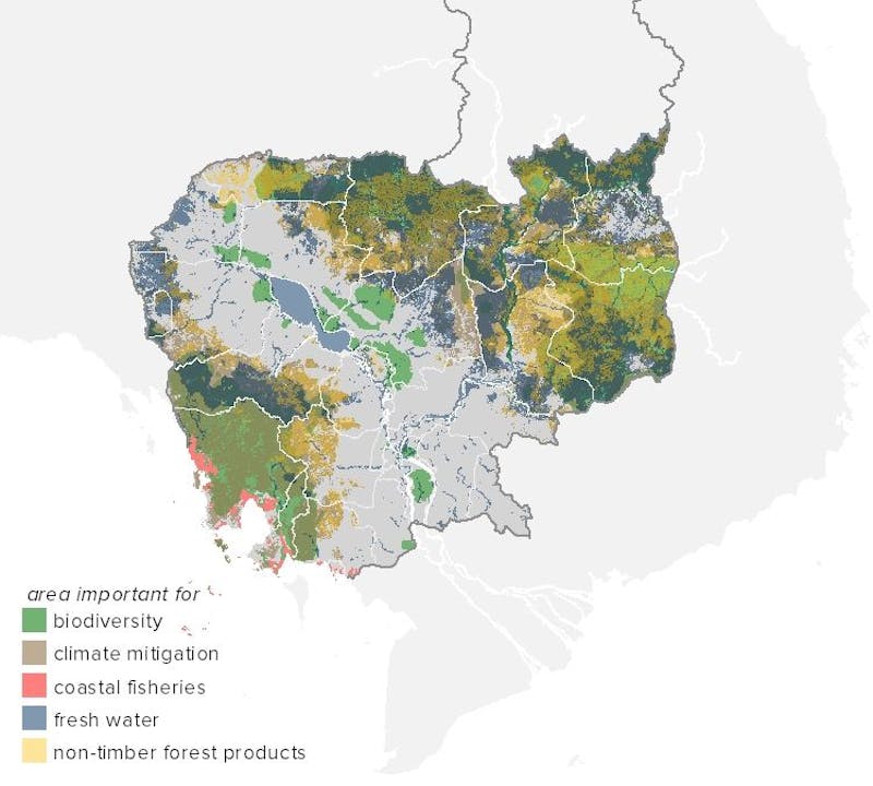
Using this method, we were able to map which areas of Cambodia are most important for various ecosystem services (see below).

Cambodia’s “essential natural capital,” broken down into five categories. (© Conservation International 2015)
Once we have mapped the location of these most important natural areas, we investigate whether they have been “sustained,” by asking three questions.
1. Are these areas officially protected?
In Cambodia, we found that 39% of essential natural capital falls within nationally designated protected areas or community forests.
Some types of natural capital are better protected than others. For example, fisheries and coastal mangroves are relatively well protected (73% and 60%, respectively). Around 53% of biodiversity priority areas fall within protected areas. However, only 39% of areas with high forest carbon stocks are protected. In addition, around 37% of areas providing essential freshwater services are protected, and around only 34% of areas important for non-timber forest products, an element of food security.
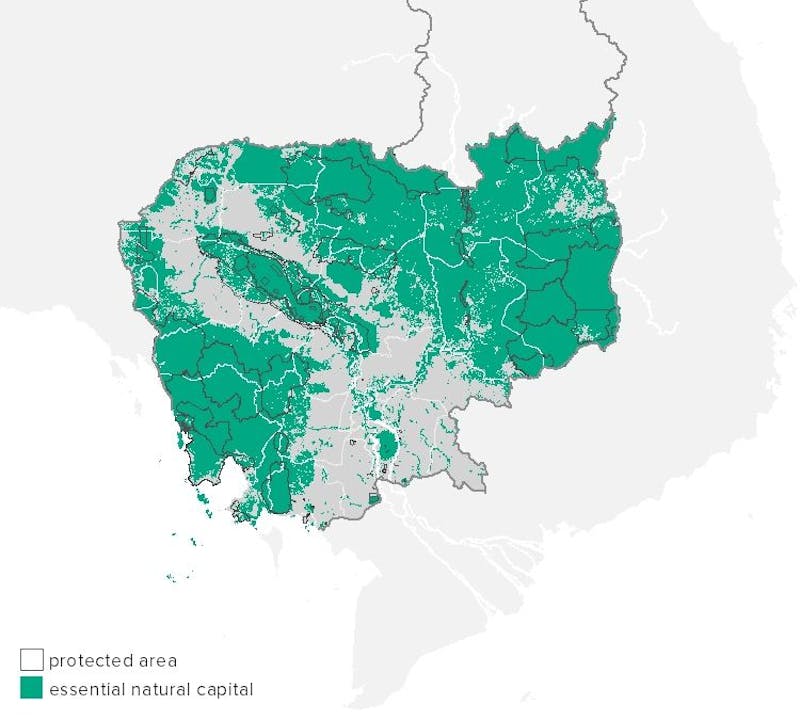
Cambodia’s protected areas are outlined in black. (© Conservation International 2015)
2. Are these areas ecologically intact?
Just because a place is protected does not mean it is effectively conserved.
We measure “ecological intactness” by analyzing satellite images of forest cover. Widespread forest loss is occurring within Cambodia’s protected area system due to illegal logging, legal clearing for economic land concessions, and small-scale agricultural expansion.
Further reading
Our results indicate that some protected areas in Cambodia are losing between 5% and 10% of their forests each year. Even if forests remain intact, hunting and other pressures can lead to species loss, resulting in “empty forest syndrome” — a situation in which almost all wildlife has been wiped out, detracting from the forest’s ability to provide benefits.
Other threats, such as planned hydropower dams, may affect Cambodia’s freshwater biodiversity, as well as the fisheries and rice production areas that are so critical to the nation’s food security. Ideally, we would have data on the ecological intactness of other ecosystems such as wetlands and coral reefs, but unfortunately those data are not available at a national scale.
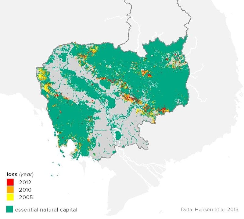
Forest loss within “essential natural capital” areas. (© Conservation International 2015
3. Are these areas effectively managed?
We measure effective management of protected areas using the Management Effectiveness Tracking Tool (METT), a scorecard developed by WWF and the World Bank. The METT includes a series of questions such as whether a management plan has been developed, and whether there is sufficient capacity and resources to manage a protected area effectively.
For Cambodia, data on management effectiveness were only available from three protected areas: the Veun Sai Siam Pang Conservation Area (56% management effectiveness), the Tonle Sap Kompong Prak Conservation Area (58%) and the Central Cardamom Protected Forest (66%). The good news is that all three protected areas increased their management effectiveness scores between 2013 and 2014, which means that they are making improvements.
All of these measurements can be used to track the status of Cambodia’s natural capital over time, and the effectiveness of efforts to conserve it.
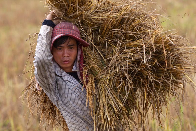
A Cambodian farmer works on a rice field in Phnom Penh, Cambodia. In order to ensure that the country can continue to provide food for its people, identifying which natural areas are most important to protect in order to maintain ecosystem services like pollination and erosion prevention is an important step. (© EPA/How Hwee Young/Alamy Stock Photo)
How will these maps help?
It’s clear there is a lot more that could be done to conserve Cambodia’s essential natural capital and ensure sustainable economic growth. We’ve shared our maps with the national government, and are already seeing some promising signs.
For example, as part of an environmental assessment of Cambodia, the Asian Development Bank — a multilateral finance institution — has requested natural capital data to help inform a national environmental action plan they are preparing for the government. Our data can create a baseline of information from which to analyze the effects of future policy changes.
The United Nations Development Program (UNDP) also requested natural capital data from CI as they set up a new ecosystem mapping and data center within Cambodia’s Ministry of Environment. Our data will provide a foundation for a larger database and information platform that UNDP will use to create their own analyses of where natural capital and biodiversity needs to be prioritized. We also hope they will use these data to create new maps for the protected area system, expanding protection and improving management and enforcement for areas that need it.
In addition to Cambodia, we recently mapped essential natural capital in Madagascar and the Amazon region of South America. Similarly, we hope to use the data we’ve gathered to bring about policy changes in those regions.
Protecting nature amid a growing, increasingly urbanized global population is no small feat — after all, we’re trying to fundamentally change how humans think about and value the Earth. But in order to implement the changes we need on this planet, it’s also essential.
As countries like Cambodia begin to take a closer look at their natural wealth, they will need data and tools to put sustainable development into action. Maps of essential natural capital can help paint a more sustainable picture, in which both people and nature thrive.